Ski Hill Project: A Case Study
Ski Run Width Assessment by Drone Surveying
The marvel about using a drone to capture imagery is the extremely high quality that can be captured compared to other methods.
It is important for ski hill operators to know:
1
Landslides
Where landslides can or have occurred.
2
Slope
Identify changes in the slope of the hill over time.
3
Snowmaking
Maintain accurate profile of the hill for installation of new snowmaking equipment.
4
Drainage
Identify areas of concern where drainage of spring runoff may be an issue.
5
Standards
Checking and maintaining widths of runs to meet race standards.
6
Infrastructure
Inspect the condition of ski lift towers and other infrastructure on the property.
Traditionally, ski hill outside operations teams would use satellite imagery, such as Google Earth, or hire an aircraft to conduct an aerial survey of the ski hill property. These traditional methods can be costly and time consuming. With the introduction of drone technology the same insight can be provided at a lower cost, making it far more beneficial to a ski hill operator.
Using a drone to capture the data allows the ski hill operator to receive up-to-date information on the status of the ski hill property for planning purposes. The high quality bird’s eye view of the entire property or sections of the property can provide insight into potential areas for future expansion, areas which may be susceptible to soil erosion and other general property maintenance issues.
Background
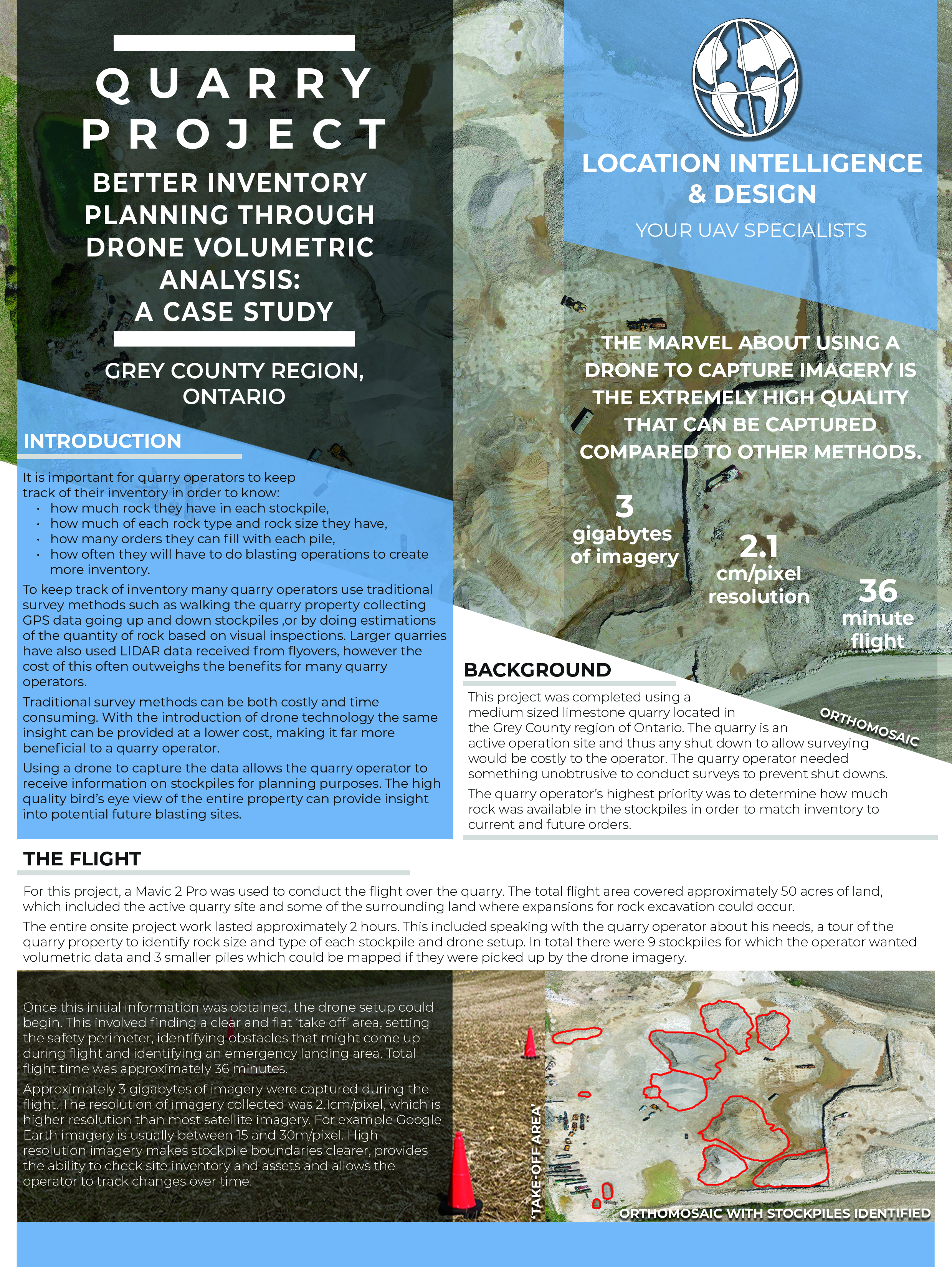
This project involved a ski hill located in the Grey County region of Ontario. The project was completed during the summer when the hill was shut down for maintenance and construction. More information can be gained from surveying in the summer as there is no snow cover obstructing the view of the hill.
The outside operations division’s priority was to map a ski run that was due to be widened in order to meet FIS Homologation requirements for the new downhill race season.
The Flight
For this project, a Mavic 2 Pro was used to conduct the flight over the ski hill. The total flight area covered approximately 14 acres of land, which included the ski run to be assessed for width and some of the surrounding land where additional assessments could be done.
The entire onsite project took approximately one(1) hour. This included speaking with the Director of Outside Operations about the needs of the project, the areas to pay attention to and drone setup. The Director of Outside Operations required width measurements around 2 sets of tree stands to determine how many trees would need to be removed and how much land would need to be graded to meet FIS requirements.
2.4
Resolution
2.4 cm/pixel
14
Acres
14 acres of land
27
Flight Time
1 battery on Mavic 2 Pro
Pre-flight
Once this initial information was obtained, the drone setup could begin. This involved finding a clear and flat ‘take off’ area, setting the safety perimeter, identifying obstacles that might come up during flight and identifying an emergency landing area. Total flight time was approximately 27 minutes.
Approximately 2.5 gigabytes of imagery was captured during the flight. The resolution of imagery collected was 2.4cm/pixel, which is a higher resolution than most satellite imagery. For example Google Earth imagery is usually between 15 and 30m/pixel. High resolution imagery makes width measurements clearer, provides the ability to check soil and slope conditions and assess infrastructure use over time.

What do you do with all that data?
Using the drone to collect the data is the easy part! Knowing what to do with it requires detailed skill and knowledge. Processing and understanding the data becomes complex when dealing with large datasets.
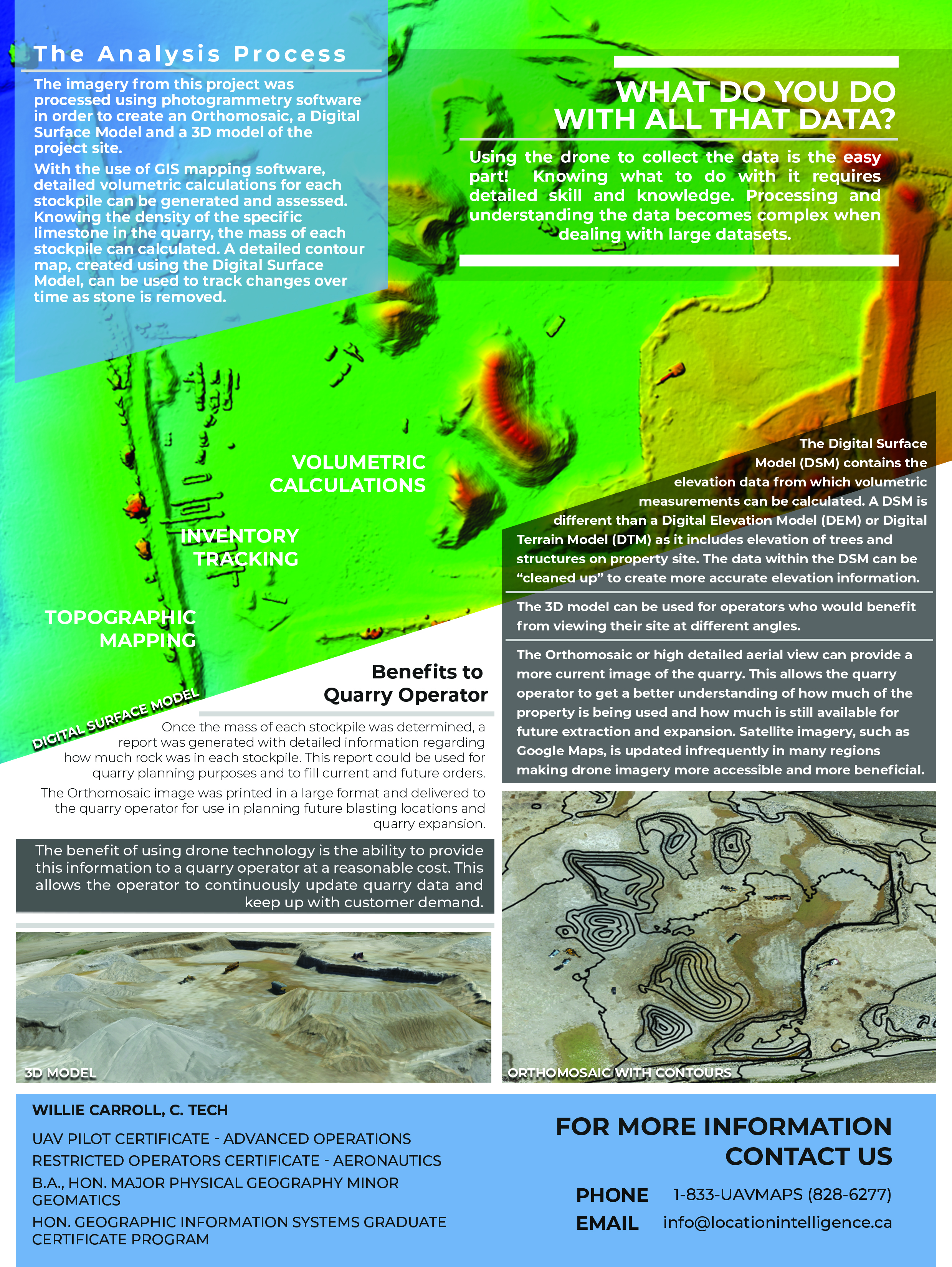
The imagery from this project was processed using photogrammetry software in order to create an Orthomosaic, a Digital Terrain Model and a 3D model of the project site.
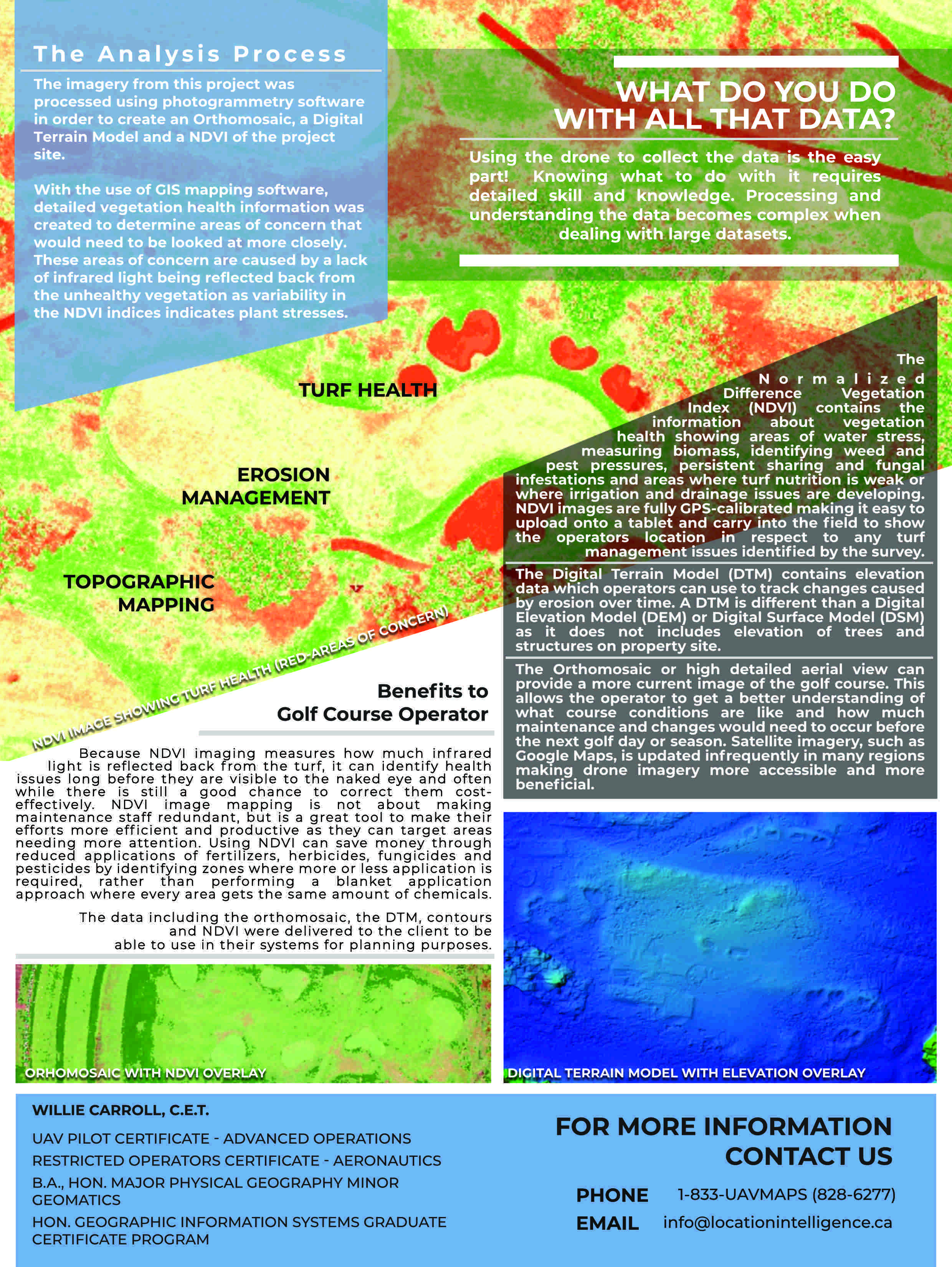
The Analysis Process:
With the use of GIS mapping software, detailed measurements were created at intervals down the run being assessed to determine how many trees would need to be removed. When submitting an application to the Niagara Escarpment Commission to get approval for ski hill changes, it is helpful to know in advance what changes are required to meet FIS standards. A detailed contour map, created using the Digital Terrain Model, can be used to track changes over time as soil moves and as water causes erosion.
Topographic Mapping

Width Measurements

Slope Monitoring
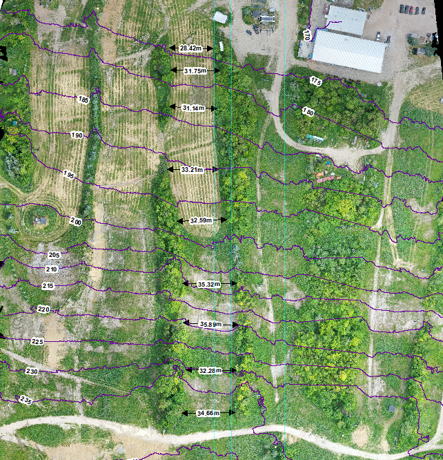
Orthomosaic with Width measurements
The Orthomosaic, or high detailed aerial view, can provide a more current image of the ski hill than can be provided by satellite imagery. This allows the operator to get a better understanding of what hill conditions are like and how much maintenance and changes would need to occur before the next ski season. Satellite imagery, such as Google Maps, is updated infrequently in many regions making drone imagery more accessible and more beneficial.
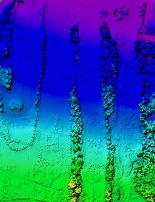
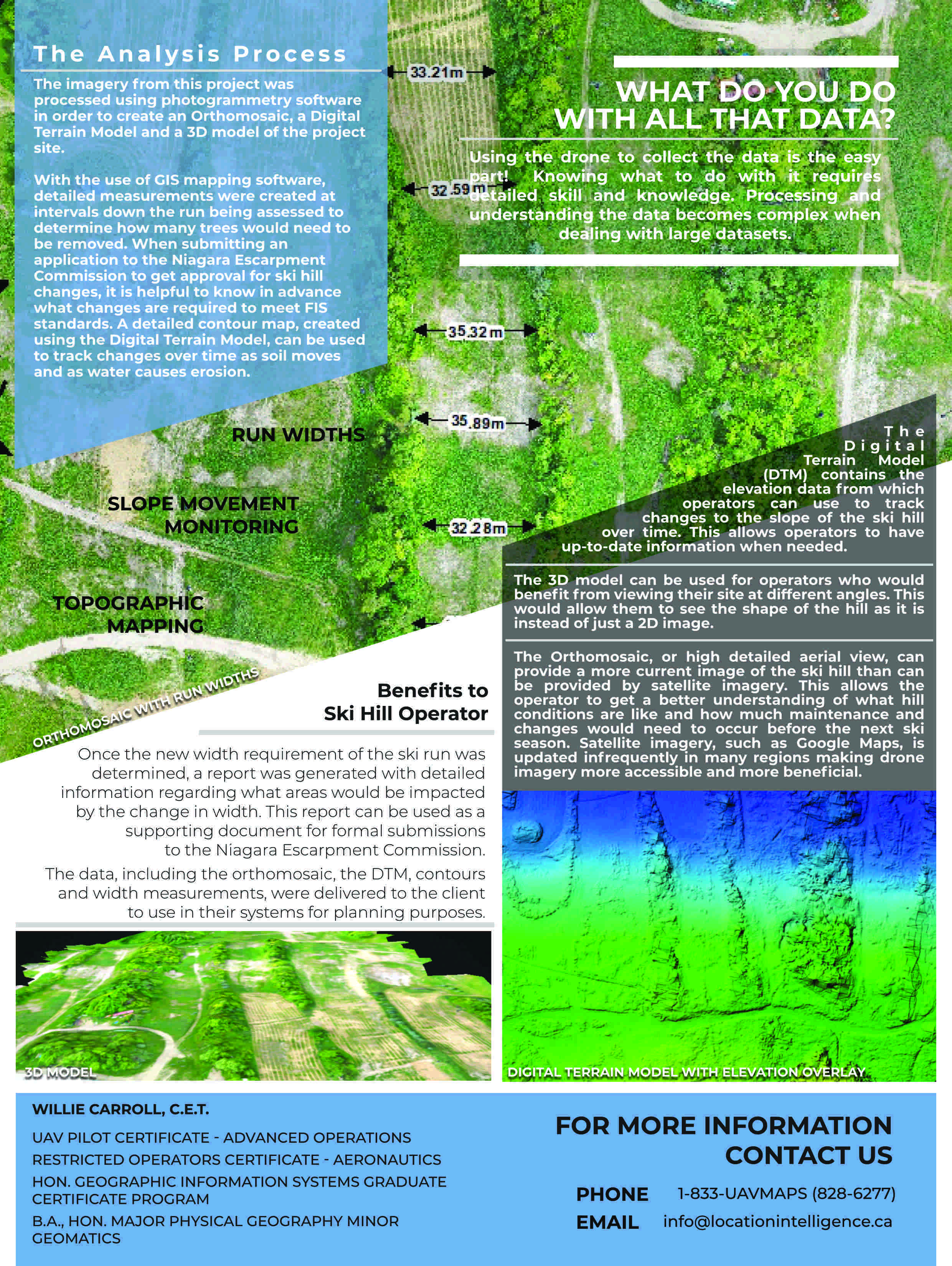
Digital Terrain Model
The Digital Terrain Model (DSM) contains elevation data which operators can use to track changes caused by erosion over time. A DTM is different than a Digital Elevation Model (DEM) or Digital Surface Model (DSM) as it does not includes elevation of trees and structures on property site.
Benefits to Ski Hill Operator
Once the new width requirement of the ski run was determined, a report was generated with detailed information regarding what areas would be impacted by the change in width. This report can be used as a supporting document for formal submissions to the Niagara Escarpment Commission.
The data, including the orthomosaic, the DTM, contours and width measurements, were delivered to the client to use in their systems for planning purposes.